

-
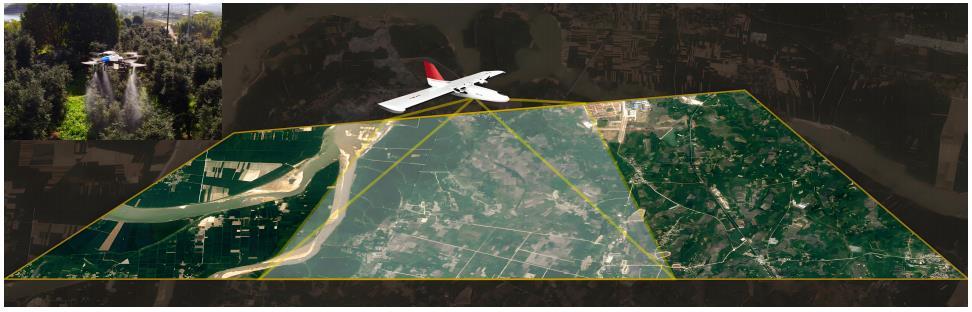
HengfeiGuizhou Hengfei Technology Co., Ltd., relying on a comprehensive and advanced full-industry-chain ecosystem thinking and industrial development concept, builds an integrated system covering general assembly integration, R&D, production and manufacturing, general aviation services, full-industry-chain services, application scenario construction, and low-altitude economic integrated application operation services derived from the industrial chain; providing professional technology, equipment supply, professional personnel, solutions, supporting facilities, and financing for comprehensive services.

-
ProductIs a low-altitude economic comprehensive operation service provider integrating the manufacturing and sales of intelligent unmanned aerial vehicles, the research and development of intelligent robots, the development of low-altitude economic application scenarios, flight training, general aviation services, surveying and mapping, technical services, and technical consulting.

-
ApplicationIs a low-altitude economic comprehensive operation service provider integrating the manufacturing and sales of intelligent unmanned aerial vehicles, the research and development of intelligent robots, the development of low-altitude economic application scenarios, flight training, general aviation services, surveying and mapping, technical services, and technical consulting.

-
R&DGuizhou Hengfei Technology Co., Ltd., relying on a comprehensive and advanced full-industry-chain ecosystem thinking and industrial development concept, builds an integrated system covering general assembly integration, R&D, production and manufacturing, general aviation services, full-industry-chain services, application scenario construction, and low-altitude economic integrated application operation services derived from the industrial chain; providing professional technology, equipment supply, professional personnel, solutions, supporting facilities, and financing for comprehensive services.
-
TrainingStarting in 2020, we began using drones in the traditional industry, and the company sent four people to learn how to fly drones and obtain pilot licenses issued by the Civil Aviation Administration. In line with the national development direction, the company initiated a transformation, conducting research and investigations into 16 low-altitude economic industries nationwide.

-
IndustryIs a low-altitude economic comprehensive operation service provider integrating the manufacturing and sales of intelligent unmanned aerial vehicles, the research and development of intelligent robots, the development of low-altitude economic application scenarios, flight training, general aviation services, surveying and mapping, technical services, and technical consulting.

-
ContactGuizhou Hengfei Technology Co., Ltd., relying on a comprehensive and advanced full-industry-chain ecosystem thinking and industrial development concept, builds an integrated system covering general assembly integration, R&D, production and manufacturing, general aviation services, full-industry-chain services, application scenario construction, and low-altitude economic integrated application operation services derived from the industrial chain; providing professional technology, equipment supply, professional personnel, solutions, supporting facilities, and financing for comprehensive services.


Smart Public Security
The ability to patrol, investigate, and strike "around the clock and in all areas"; big data visualization analysis, system automatic identification and early warning; real-time grasp of dynamics, maximizing police efficiency; a three-dimensional patrol model of "air + ground", realizing all-round and seamless patrol; realizing effective integration of data across police types, departments, and systems to establish a sound information chain management; intelligent prediction and analysis in command and dispatch, police deployment, and security prevention, to develop more detailed work plans.

Intelligent Transportation
Low cost and quick and convenient image acquisition; high efficiency and rapid response; strong anti-interference ability of the equipment; seamless docking with the video surveillance system; strong mobility and good work continuity; less affected by climate and geographical conditions; much stronger video transmission capability; multi-departmental joint data sharing and common viewing

Intelligent Emergency Response
Real-time monitoring of on-site footage, aggregation of various disaster information to aid rescue efforts; promoting the intelligent transformation of emergency rescue equipment, contributing to the construction of an intelligent emergency response system; mobile and flexible, improving the efficiency of emergency rescue material transportation, buying valuable time for rescue; effectively ensuring the safety of rescue personnel; significantly improving the efficiency of emergency rescue; quickly analyzing real-time disaster situations to provide decision-making basis for the deployment of emergency rescue forces; accurate post-disaster analysis to provide data support for post-disaster reconstruction; high degree of timeliness and accuracy, significantly reducing costs, reducing inspection rates, and reducing inefficient manual labor output

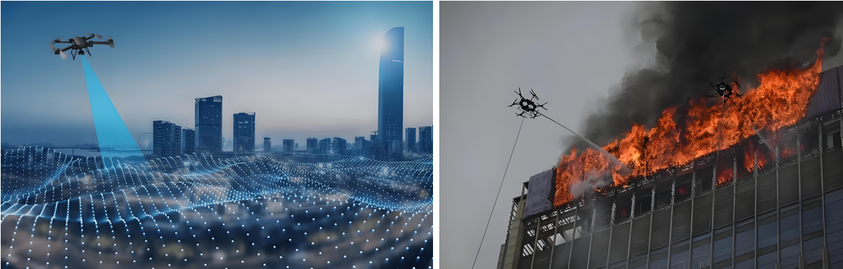
Intelligent Firefighting
Visualized data assists in the orderly progress of assessment and repair work; replacing manual large-scale inspection work, reducing labor costs, and improving inspection efficiency
Smart City Management
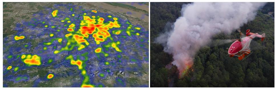
Visually displays the distribution and location of illegal constructions; Provides a decision-making basis for the urban management department to formulate governance plans; Visualizes data, enabling data scheduling and traceability; Integrates GIS technology to achieve digital management of urban assets; Breaks down barriers between multiple departments; Empowers urban planning and layout needs; Visualized three-dimensional base realizes transparent urban management; An orderly closed-loop processing process efficiently empowers urban management; Significantly improves the frequency and scope of inspections, reducing the rate of missed inspections

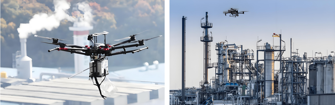
Intelligent Environmental Protection
Comprehensive monitoring, reducing monitoring difficulty, increasing monitoring coverage, and avoiding blind spots in random checks; the distribution of gas emissions is clear at a glance, quickly identifying pollution sources; improving patrol efficiency to ensure detection without blind spots; comprehensively controlling environmental conditions and promptly eliminating pollution risks; a three-dimensional perspective provides a visual basis for decision-making in environmental remediation; significantly reducing input costs and improving regulatory efficiency

Smart Agriculture
Improve work efficiency and avoid errors caused by manual measurement; scientifically manage farmland, allowing managers to clearly understand the nutrient content of the land; improve operational efficiency, reduce costs, and free up labor; provide accurate data to ensure the accuracy of farmland compensation.

Smart Power
Complete inspection tasks quickly and accurately, improving work efficiency; reduce risks to personnel, avoiding safety hazards such as falls from heights, and improving work safety; not limited by complex terrain and environment, able to perform tasks in harsh weather and terrain conditions; support fully automated inspection programs to ensure data reliability.

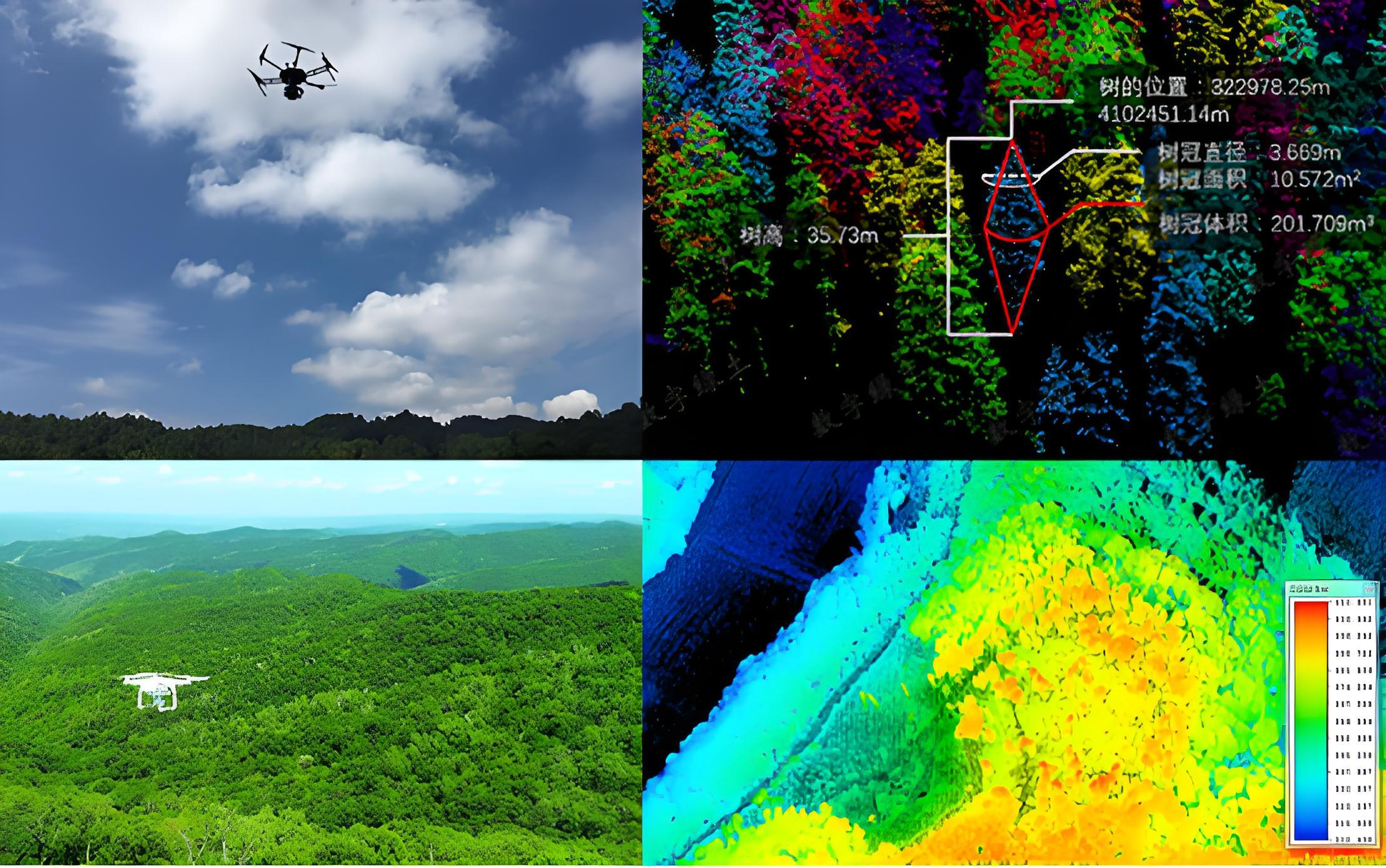
Intelligent Aerial Surveying
Intelligent aerial surveying is a method of aerial surveying that integrates advanced technologies. Compared with traditional aerial surveying, it has many advantages in terms of efficiency, accuracy, and data processing.
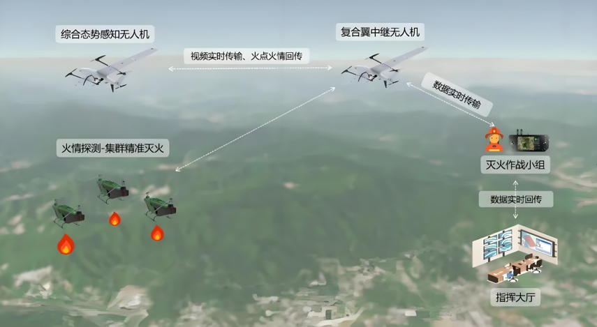
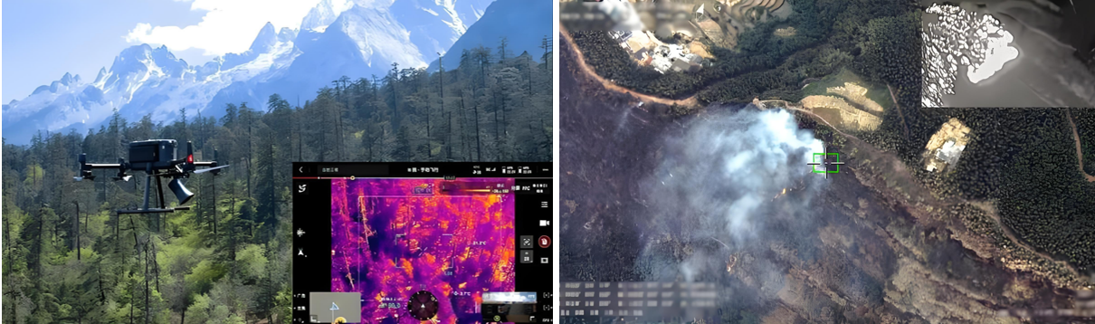
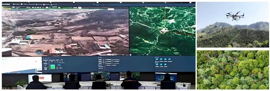
Intelligent Firefighting
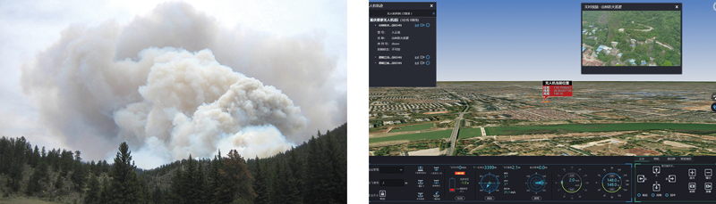
Fire Prevention Patrol
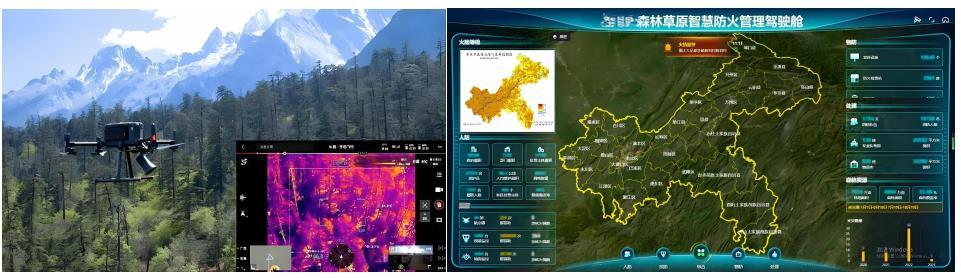
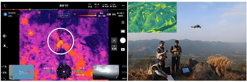
Regular drone patrols transmit real-time footage to the command center. The discovery and investigation of unknown smoke during a patrol prevented a fire, ensuring forest fire safety.
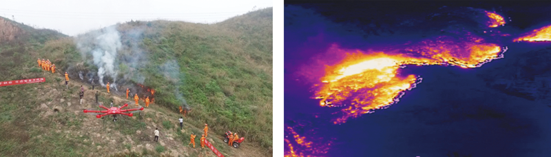
Drone Fire Rescue Auxiliary Service
Assisted in a fire scene. A drone equipped with a high-definition infrared thermal imaging camera monitored the fire for an extended period, transmitting real-time data to the command center to provide visualized data for deployment of fire extinguishing plans and command and dispatch.
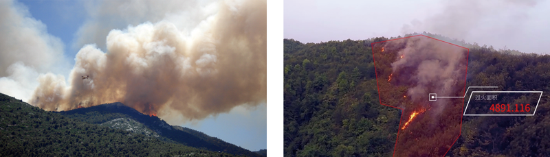
Drone Post-Fire Investigation Service
A wildfire raged, spreading to the forests of three towns. With the efforts of the local forest fire brigade and other forces, the fire was successfully extinguished. After the fire, the forest fire brigade completed the collection of geographic information for the 52-square-kilometer burned area in less than an hour and completed post-disaster analysis and assessment through the platform, submitting it to the forest fire brigade and receiving commendation.
Solution Value
☆ Visualized data assists in the orderly progress of assessment and repair work
☆ Replaces manual large-scale patrols, reducing labor costs and improving patrol efficiency
Smart Public Security Solution
 |
 |
 |
 |
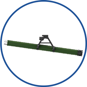 |
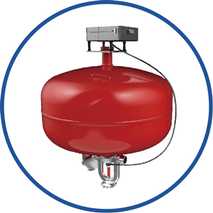
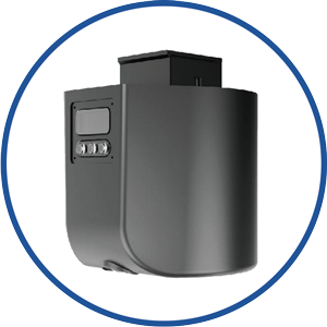
| Flight Platform | Gimbal | Fire Extinguishing Projectile | Throwing Equipment | Rescue Equipment |
Drone Firefighting Application Scenarios
“How to Prevent” Building an Intelligent Fire Prevention System
Drones, through dynamic monitoring, hazard identification, and early warning, form an integrated “air-ground-earth” prevention network in fire prevention.
Routine Hazard Inspection | Forest/Grassland Fire Prevention
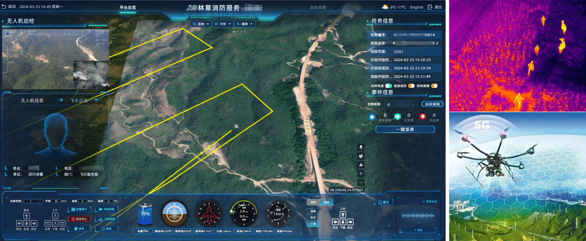
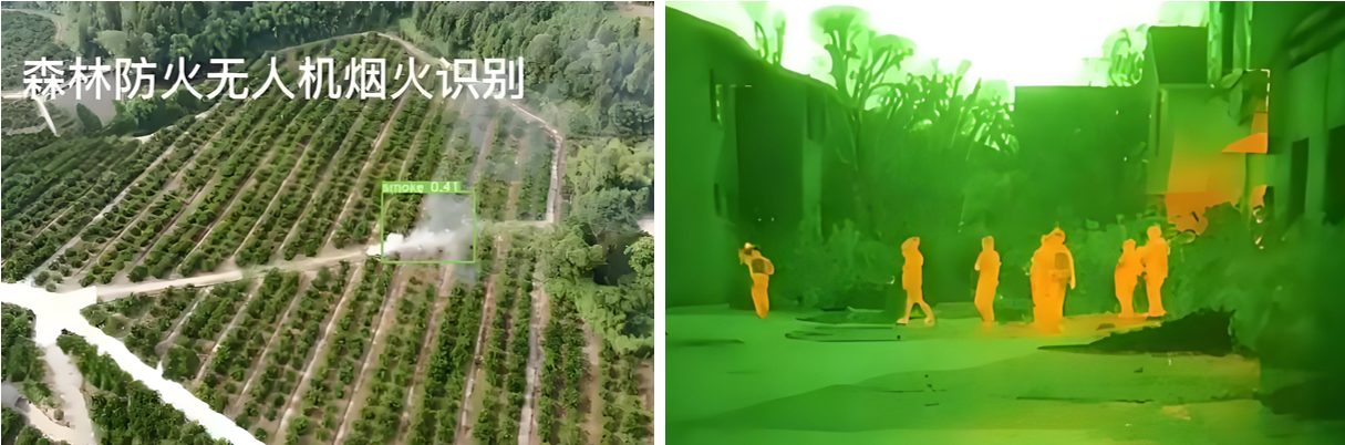
Drones conduct grid-based inspections of forest areas along preset routes, equipped with visible light cameras and infrared thermal imagers to automatically identify early signs of fire such as smoke and high-temperature points. At fire risk level 3 and above, at least two automatic patrols are conducted daily; the frequency is increased to once per hour during the key fire prevention period.

Routine Hazard Inspection | Urban High-Rise Buildings
Multispectral scanning of high-rise building exteriors, electrical equipment, gas pipelines, and other hazardous areas is conducted to identify problems such as flammable material accumulation and circuit aging using AI algorithms. LiDAR is used to construct a 3D model of the building to assess risks such as blocked fire lanes and ineffective fire compartments.
Routine Hazard Inspection | Fire Risk Warning and Pre-treatment
Drones equipped with meteorological sensors monitor parameters such as wind speed, humidity, and temperature in real-time, and predict fire risk levels based on historical data. Upon discovering hazards, they immediately warn nearby personnel using a loudspeaker and throw fire-retardant agents or activate miniature sprinkler systems to contain nascent fires.
Routine Hazard Inspection | Contingency Plan Rehearsal and Training
Geographic information data collected by drones is used to generate a digital sand table to simulate the spread path under different fire scenarios and optimize emergency plans. Simulated smoke bombs are thrown during drills to test the response speed and coordination of firefighting teams.
“How to Patrol” Efficient and Accurate Stereoscopic Inspection
Drones overcome terrain limitations and achieve all-weather, all-terrain fire monitoring using multimodal payloads.
Intelligent Cruise Technology | Autonomous Flight System
Supports automatic takeoff and landing, route planning, and obstacle avoidance, with a coverage radius of up to 15 kilometers and a flight time exceeding 2 hours. A “frog-jumping” multi-nest deployment strategy is adopted, extending operation time through mobile charging stations (e.g., deploying one nest point every 3.2 kilometers in forest scenarios).
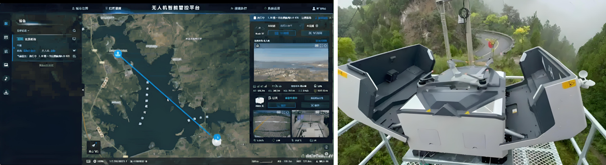
Intelligent Cruise Technology | Real-time Data Transmission
5G/satellite communication technology enables real-time transmission of 1080P high-definition video and thermal imaging data to the command center with a latency of less than 500 milliseconds.
Multi-dimensional Fire Monitoring | Visible Light + Infrared Fusion
During the day, a 30x optical zoom lens is used to identify tiny smoke; at night, a thermal imager detects a temperature difference of 0.5℃.
Multi-dimensional Fire Monitoring | Gas Detection
In chemical fire scenarios, a PID sensor is used to detect VOC concentrations and delineate the diffusion range of hazardous gases such as benzene and hydrogen sulfide.
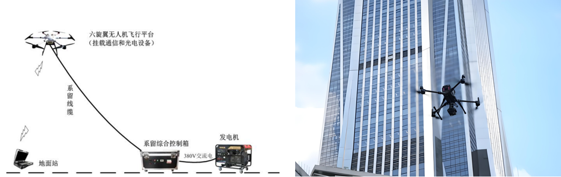
Special Scenario Enhancement Plan | High-Rise Buildings
Tethered drones are used to achieve 24-hour airborne monitoring, with fiber optic power supply ensuring continuous operation.
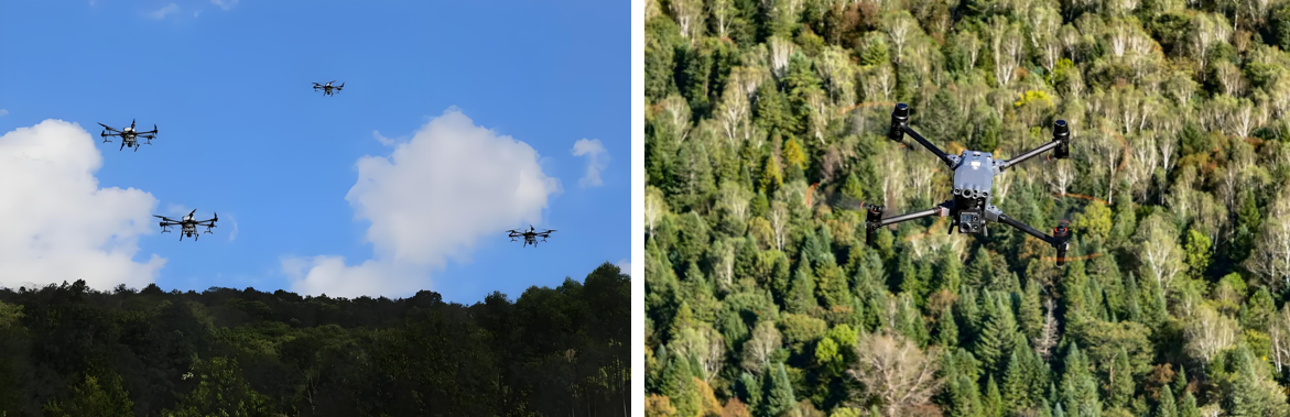
Special Scenario Enhancement Plan | Forest Fires
A cluster of drones performs an “8-shaped” search, with each drone covering a different area to achieve complete coverage.
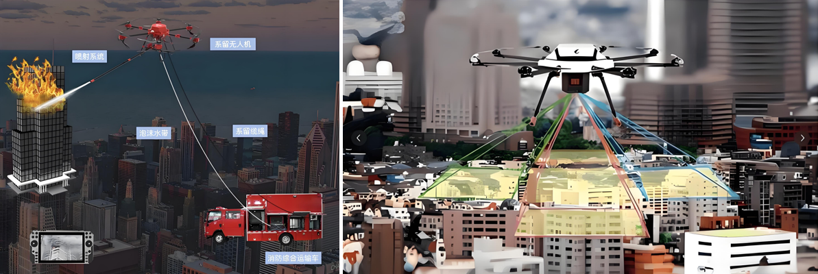
“How to Rescue” Air-Ground Collaborative Emergency Rescue System
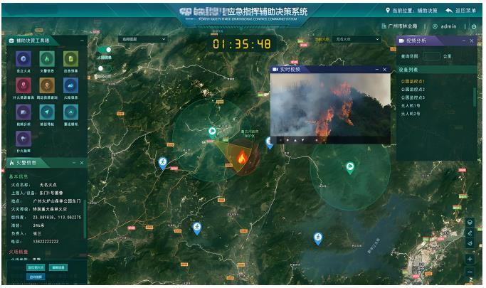
Fire Scene Reconnaissance and Decision Support | Rapid Situational Awareness
A full-chain action plan of “reconnaissance-suppression-rescue-post-event” is constructed to minimize casualties and property losses.
The first arriving drones drop positioning beacons to generate a digital twin model of the fire scene, marking the location of the fire source, trapped personnel, and explosives.
Fire Scene Reconnaissance and Decision Support | Tactical Planning
Three-dimensional modeling recommends the optimal attack route, coordinating high-spray fire trucks to accurately strike fire points above the 15th floor (error ±0.5 meters).
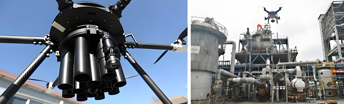
Active Firefighting Action | High-Altitude Suppression
Drones carrying dry powder tanks implement a “water mist curtain” isolation tactic at an altitude of 100 meters, with a cooling rate of 200℃/minute.

Active Firefighting Action | Special Scene Handling
In chemical tank farms, explosion-proof drones are used to drop gel fire suppressants, forming a 3cm thick covering layer to prevent boilover.
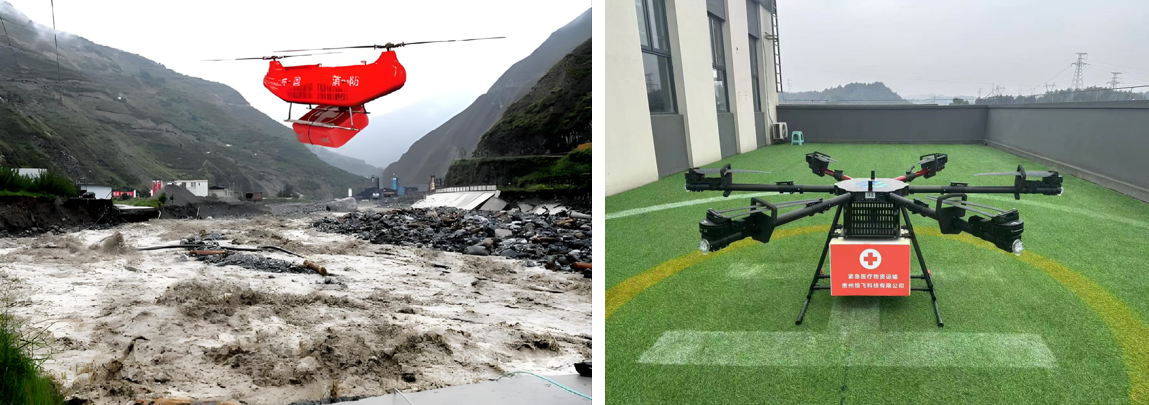
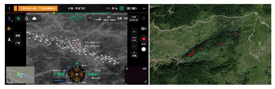
● Personnel Search and Rescue and Material Delivery | Life Detection
Equipped with radar to penetrate 20cm of concrete rubble, combined with a microphone array to achieve voice localization of trapped persons within a 10-meter range.

● Personnel Search and Rescue and Material Delivery | Emergency Delivery
A hexacopter drone (payload 60kg) delivers emergency breathing masks, first-aid kits, etc., with an accuracy of 0.3m.
● Personnel Search and Rescue and Material Delivery | Escape Guidance
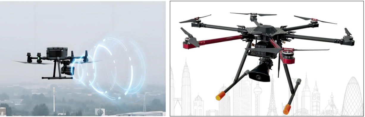
Guides evacuation routes through LED subtitle projection and directional sonic speakers; supports multilingual announcements.
● Secondary Disaster Prevention
After extinguishing the fire, the drone continuously monitors the residual temperature. If hotspots above 50℃ are detected, secondary cooling is immediately triggered. After the disaster, a multispectral camera is used to assess building structural damage and mark D-class dangerous houses.
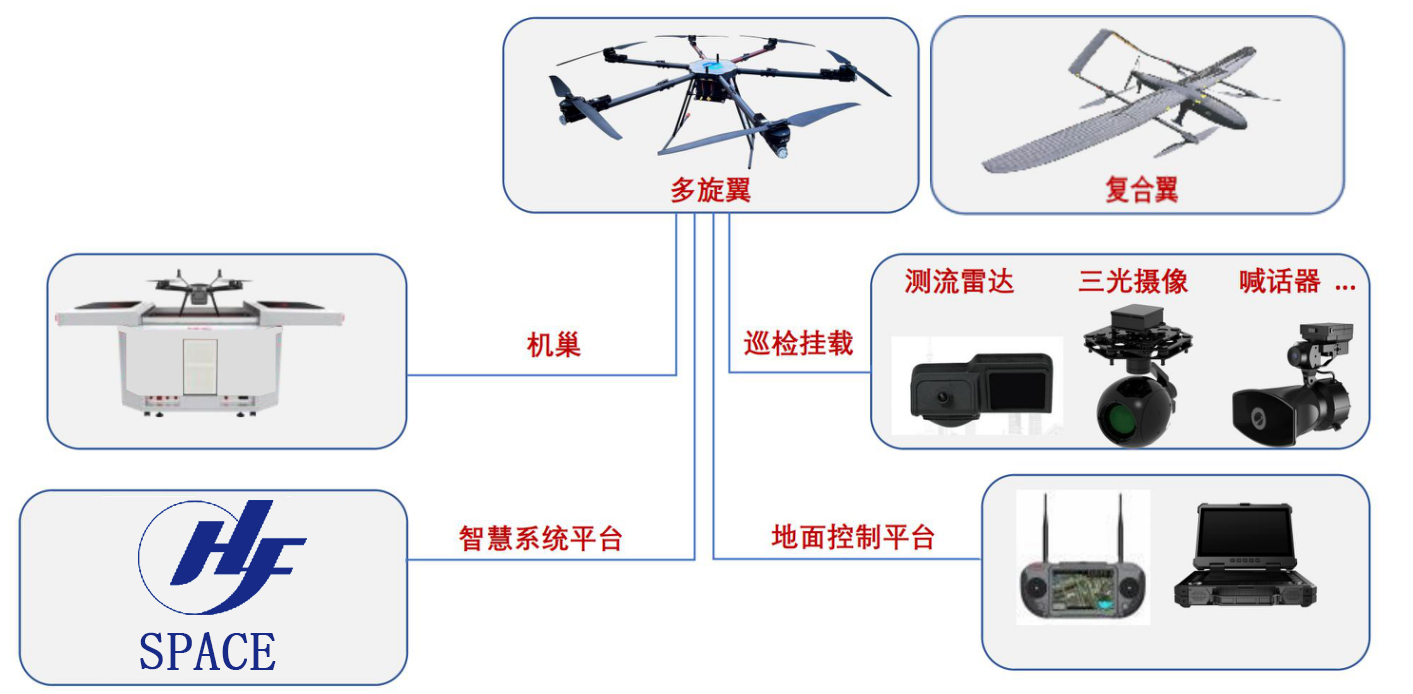
Routine Inspection | Equipment
Drone + Docking Station
Drone Forestry Application Solution
How to Prevent: Constructing a 24/7 Stereoscopic Forest Protection Network
● Daily Hidden Danger Inspection | Inspection Content
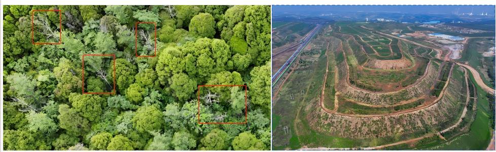
Forest Resource Survey and Monitoring:Drones use high-resolution remote sensing technology to quickly obtain data on forest area, volume, and biomass, significantly improving the efficiency of traditional manual surveys.
Especially in steep or complex terrain, drones can replace high-risk manual operations, solving safety hazards in scenarios such as seed collection and patrolling.
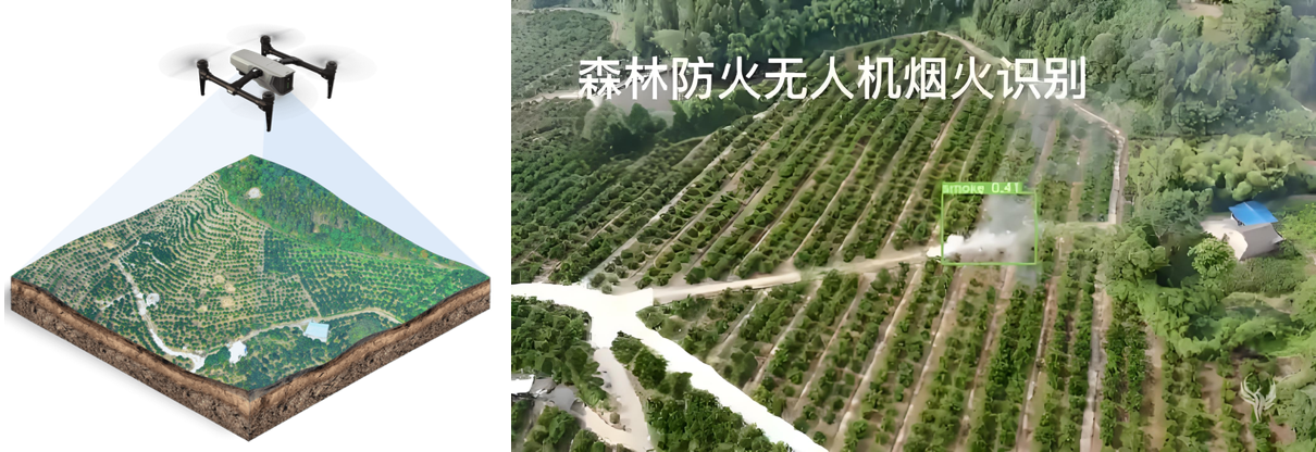
Forest Fire Early Warning and Fire Source Monitoring
Dual-light Fusion Technology: Combining visible light and thermal imaging for all-weather fire monitoring. For example: The payload can penetrate smoke at night to identify hidden fire sources.
Intelligent Alarm System: Automatically analyzes image data, triggers fire alarms, and synchronizes coordinates to the command center.
Intelligent Diagnosis and Prevention of Pests and Diseases
Precise Application: Equipped with atomizing nozzles, combined with route planning to achieve grid spraying, reducing drug waste.
Data Modeling: Generates a three-dimensional forest model using LiDAR to locate high-incidence areas of pests and diseases.
Ecological Protection and Wildlife Monitoring
AI Recognition Algorithm: Automatically identifies rare species and counts populations.
Habitat Protection: Evaluates ecological restoration effects through aerial photography data and guides vegetation restoration projects.
How to Patrol: Intelligent Inspection System Improves Forest Management Efficiency
● Daily Hidden Danger Inspection | Inspection Content
Daily Patrol Mode Innovation
Route Planning and Automated Inspection: Based on the GIS system, routes are planned, and drones automatically cover a 50-meter range on both sides of the route. A single task can inspect 2000 mu of forest land, taking only 10 minutes, improving efficiency by 12 times compared to manual inspection.
Complex Terrain Breakthrough: Drones can traverse dense forests and cliffs, using LiDAR obstacle avoidance technology to ensure flight safety.
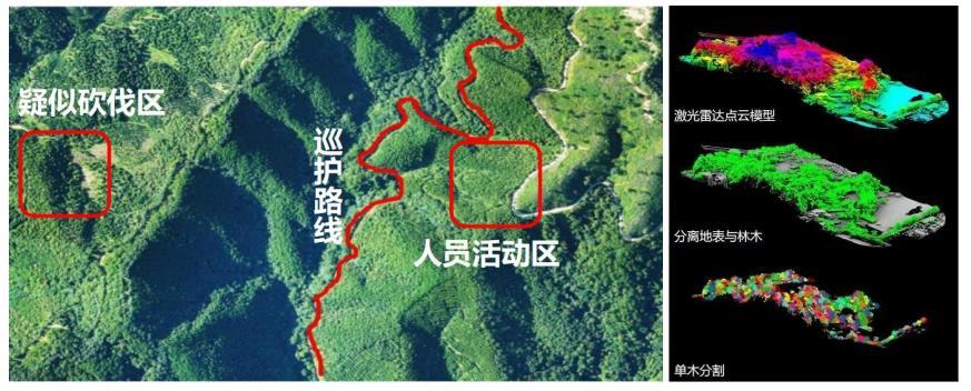
Resource Survey and Law Enforcement Supervision
Forest Land Occupancy Monitoring: Regularly comparing aerial imagery to detect illegal land occupation and deforestation.
Law Enforcement Evidence Collection: Equipped with a 20-megapixel camera to take high-definition evidence and transmit it in real-time, supporting forestry administrative penalties.
Flood Season and Geological Disaster Prevention:During the flood season, drones monitor river water levels and landslide risks in real-time, and assist emergency departments in responding quickly through real-time image transmission.
How to Rescue: Air-Ground Collaborative Emergency Rescue System
● Daily Hidden Danger Inspection | Inspection Content
Forest Fire Emergency Response
Fire Scene Investigation and Command Assistance: Drones generate real-time three-dimensional heat maps over the fire scene, marking the fire line length and direction of spread, providing decision-making support for the command center.
Material Delivery and Communication Relay: Large drones can deliver fire extinguishing bombs and first-aid kits, and build temporary communication networks to ensure the coordination of rescue teams.
Personnel Search and Rescue and Emergency Linkage
Missing Person Localization: Equipped with thermal imaging and a loudspeaker, drones can quickly locate trapped persons during night-time search and rescue.
Air-Ground Collaborative Firefighting: Pilots, ground fire fighting teams, and the command center share data in real-time via 5G, achieving a closed loop of "discovery—location—extinguishing".
Post-Disaster Assessment and Ecological Restoration
Disaster Loss Survey: Drones generate high-precision orthophotos to quickly assess the burnt area and timber losses.
Restoration Monitoring: Regularly track vegetation restoration progress through aerial photography and guide replanting and soil and water conservation projects.
Equipment Configuration
● Routine Inspection | Equipment
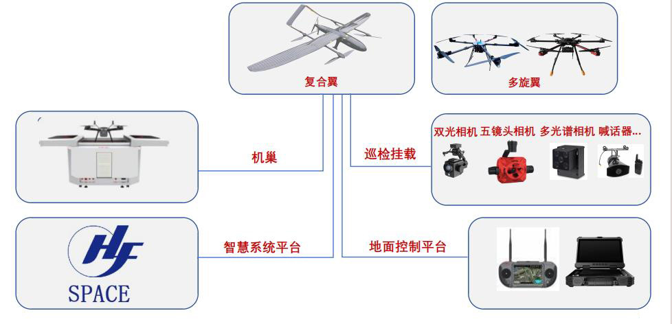
I. Platform Construction
This system mainly includes AI video intelligent analysis system, mobile video management and analysis, drone video management and section analysis, and radar data intelligent analysis.
Through the construction of a command intelligence platform,Realize task setting, route planning, automatic identification, risk warning data storage and processing, forestry inspection, emergency command, and illegal evidence collectionetc.
II. BIM Information Entry
Using a modular architecture, a basic application support platform is built, including BIM models, GIS data, BIM+GIS engine, BPM process engine, BI analysis tools, integrated communication system, unified identity authentication service, digital twin engine, simulation decision engine, BeiDou high-precision positioning service, etc., providing support for various businesses in the SaaS (business application layer).
Regular Inspection | Full Coverage Inspection Equipment
3. UAV + Nest
Contact us for more details
HENGFEI TECHNOLOGY look forward to working with you to create a better future!
- All
- Product Management
- News
- Introduction
- Enterprise outlets
- FAQ
- Enterprise Video
- Enterprise Atlas
Low-altitude economy integrated operation service center
HENGFEI TECHNOLOGY
Telephone:183-0095-0096 (Mr. Deng)
157-6163-4439(Mr. Gao)
E-mail:418903183@qq.com
Operating Headquarters: 24th Floor, Lie Yi International Plaza Office Building, 318 Jinyang North Road, Guanshan Lake District, Guiyang City, Guizhou Province
Production Base: 4th Floor, Factory Building 10, Jinhua Town Intelligent Network Automobile Industrial Park (Nanyuan), Guanshan Lake District, Guiyang City, Guizhou Province
Focus on us
Sweep and add customer service
Copyright © Guizhou Hengfei Technology Co., Ltd. 2025 (gzhfkj.net) All Rights Reserved. Website Construction:Zhonqi Power Guiyang