

-
HengfeiGuizhou Hengfei Technology Co., Ltd., relying on a comprehensive and advanced full-industry-chain ecosystem thinking and industrial development concept, builds an integrated system covering general assembly integration, R&D, production and manufacturing, general aviation services, full-industry-chain services, application scenario construction, and low-altitude economic integrated application operation services derived from the industrial chain; providing professional technology, equipment supply, professional personnel, solutions, supporting facilities, and financing for comprehensive services.

-
ProductIs a low-altitude economic comprehensive operation service provider integrating the manufacturing and sales of intelligent unmanned aerial vehicles, the research and development of intelligent robots, the development of low-altitude economic application scenarios, flight training, general aviation services, surveying and mapping, technical services, and technical consulting.

-
ApplicationIs a low-altitude economic comprehensive operation service provider integrating the manufacturing and sales of intelligent unmanned aerial vehicles, the research and development of intelligent robots, the development of low-altitude economic application scenarios, flight training, general aviation services, surveying and mapping, technical services, and technical consulting.

-
R&DGuizhou Hengfei Technology Co., Ltd., relying on a comprehensive and advanced full-industry-chain ecosystem thinking and industrial development concept, builds an integrated system covering general assembly integration, R&D, production and manufacturing, general aviation services, full-industry-chain services, application scenario construction, and low-altitude economic integrated application operation services derived from the industrial chain; providing professional technology, equipment supply, professional personnel, solutions, supporting facilities, and financing for comprehensive services.
-
TrainingStarting in 2020, we began using drones in the traditional industry, and the company sent four people to learn how to fly drones and obtain pilot licenses issued by the Civil Aviation Administration. In line with the national development direction, the company initiated a transformation, conducting research and investigations into 16 low-altitude economic industries nationwide.

-
IndustryIs a low-altitude economic comprehensive operation service provider integrating the manufacturing and sales of intelligent unmanned aerial vehicles, the research and development of intelligent robots, the development of low-altitude economic application scenarios, flight training, general aviation services, surveying and mapping, technical services, and technical consulting.

-
ContactGuizhou Hengfei Technology Co., Ltd., relying on a comprehensive and advanced full-industry-chain ecosystem thinking and industrial development concept, builds an integrated system covering general assembly integration, R&D, production and manufacturing, general aviation services, full-industry-chain services, application scenario construction, and low-altitude economic integrated application operation services derived from the industrial chain; providing professional technology, equipment supply, professional personnel, solutions, supporting facilities, and financing for comprehensive services.


Smart Public Security
The ability to patrol, investigate, and strike "around the clock and in all areas"; big data visualization analysis, system automatic identification and early warning; real-time grasp of dynamics, maximizing police efficiency; a three-dimensional patrol model of "air + ground", realizing all-round and seamless patrol; realizing effective integration of data across police types, departments, and systems to establish a sound information chain management; intelligent prediction and analysis in command and dispatch, police deployment, and security prevention, to develop more detailed work plans.

Intelligent Transportation
Low cost and quick and convenient image acquisition; high efficiency and rapid response; strong anti-interference ability of the equipment; seamless docking with the video surveillance system; strong mobility and good work continuity; less affected by climate and geographical conditions; much stronger video transmission capability; multi-departmental joint data sharing and common viewing

Intelligent Emergency Response
Real-time monitoring of on-site footage, aggregation of various disaster information to aid rescue efforts; promoting the intelligent transformation of emergency rescue equipment, contributing to the construction of an intelligent emergency response system; mobile and flexible, improving the efficiency of emergency rescue material transportation, buying valuable time for rescue; effectively ensuring the safety of rescue personnel; significantly improving the efficiency of emergency rescue; quickly analyzing real-time disaster situations to provide decision-making basis for the deployment of emergency rescue forces; accurate post-disaster analysis to provide data support for post-disaster reconstruction; high degree of timeliness and accuracy, significantly reducing costs, reducing inspection rates, and reducing inefficient manual labor output

Intelligent Firefighting
Visualized data assists in the orderly progress of assessment and repair work; replacing manual large-scale inspection work, reducing labor costs, and improving inspection efficiency
Smart City Management
Visually displays the distribution and location of illegal constructions; Provides a decision-making basis for the urban management department to formulate governance plans; Visualizes data, enabling data scheduling and traceability; Integrates GIS technology to achieve digital management of urban assets; Breaks down barriers between multiple departments; Empowers urban planning and layout needs; Visualized three-dimensional base realizes transparent urban management; An orderly closed-loop processing process efficiently empowers urban management; Significantly improves the frequency and scope of inspections, reducing the rate of missed inspections

Intelligent Environmental Protection
Comprehensive monitoring, reducing monitoring difficulty, increasing monitoring coverage, and avoiding blind spots in random checks; the distribution of gas emissions is clear at a glance, quickly identifying pollution sources; improving patrol efficiency to ensure detection without blind spots; comprehensively controlling environmental conditions and promptly eliminating pollution risks; a three-dimensional perspective provides a visual basis for decision-making in environmental remediation; significantly reducing input costs and improving regulatory efficiency

Smart Agriculture
Improve work efficiency and avoid errors caused by manual measurement; scientifically manage farmland, allowing managers to clearly understand the nutrient content of the land; improve operational efficiency, reduce costs, and free up labor; provide accurate data to ensure the accuracy of farmland compensation.

Smart Power
Complete inspection tasks quickly and accurately, improving work efficiency; reduce risks to personnel, avoiding safety hazards such as falls from heights, and improving work safety; not limited by complex terrain and environment, able to perform tasks in harsh weather and terrain conditions; support fully automated inspection programs to ensure data reliability.

Intelligent Aerial Surveying
Intelligent aerial surveying is a method of aerial surveying that integrates advanced technologies. Compared with traditional aerial surveying, it has many advantages in terms of efficiency, accuracy, and data processing.
Smart Public Security
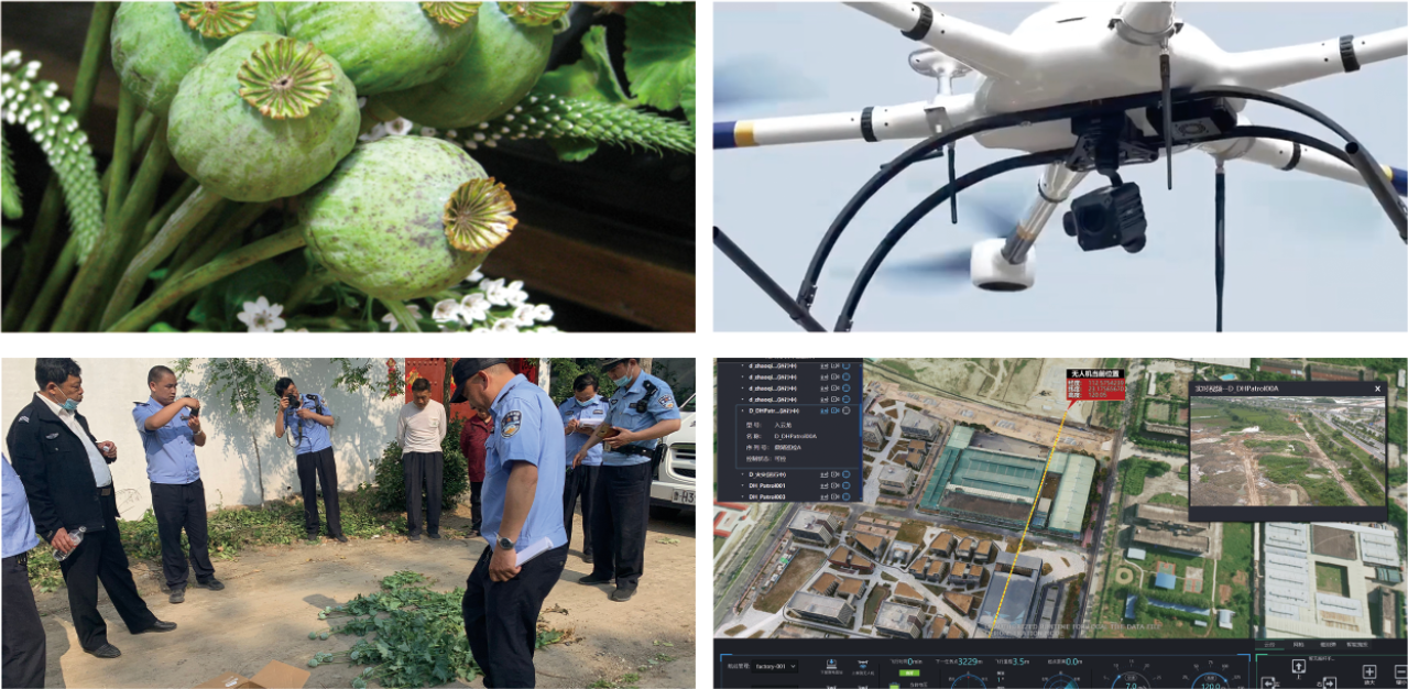
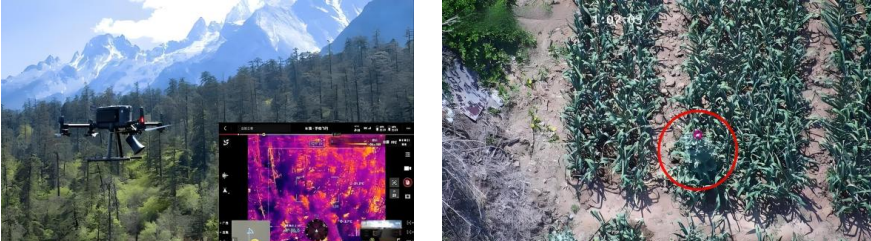
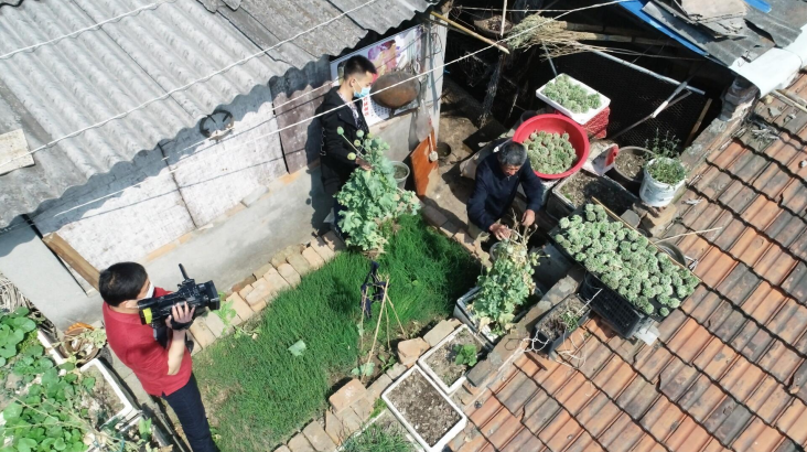
● Public Security System's "Sky Eye Drug Elimination" Operation
Public security departments used drones for cross-type random area patrols to combat opium poppy cultivation. In a four-day operation, 35 drone sorties were conducted. Without prior planning, 183 opium poppy plants were seized on-site.
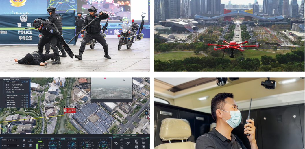
● Drone Response to Violent Incidents
A violent incident occurred, and the Ministry of Public Security apprehended the suspect. A multirotor drone, equipped with a gimbal, tracked the suspect and transmitted real-time location information. Ground personnel, based on the key information provided by the drone, deployed in advance and successfully apprehended the suspect. This fully demonstrated the advantages of air-ground coordinated operations and avoided the waste of police resources.
● Solution Value
☆ "All-weather, all-field" patrol, reconnaissance, and strike capabilities
☆ Big data visualization analysis, system automatic identification and early warning
☆ Real-time grasp of dynamics, maximizing police efficiency
☆ A three-dimensional patrol model of "air + ground", achieving comprehensive and gapless patrols
☆ Realizing the effective integration of data across police forces, departments, and systems to establish and improve information chain management
☆ Conducting intelligent predictive analysis on command and dispatch, police deployment, and security prevention to develop more detailed work plans
● Smart Public Security Solution
 |
 |
 |
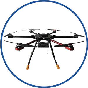
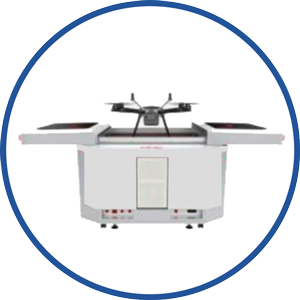
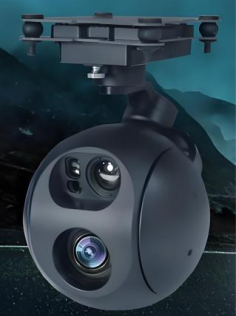
| Flight Platform | Drone manned hangar | Multipurpose drone payload |
 |
 |
|
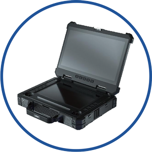
| Ground Control Platform | Intelligent system platform |
Smart Public Security - Drone Opium Poppy Inspection Plan
I. Technical Solution and Equipment Configuration
1. Multispectral/Hyperspectral Identification:
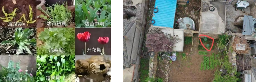
By equipping drones with multispectral cameras or hyperspectral equipment to collect the spectral characteristics of opium poppy plants, combined with background suppression algorithms, opium poppies can be accurately identified in complex environments, especially when in the seedling stage or mixed with other crops. For example, the drone patrol system uses a multispectral screening + visible light identification mode, with an identification accuracy rate of over 90%.
 |
 |
| Multispectral Lens Camera | Hyperspectral Lens Camera |
2. Multifunctional Payload Integration:
Drones can be equipped with high-definition zoom gimbals (for detailed evidence collection), infrared thermal imaging (for night monitoring), and loudspeakers (for publicity and warnings), adapting to different scene needs.
II. Patrol Process and Implementation Steps
1. Data Acquisition:
1.1. Preset flight routes and use drones for high-altitude three-dimensional patrols of key areas (such as fields, abandoned courtyards, rooftops, etc.).
1.2. Collect images through multispectral/hyperspectral equipment and simultaneously record coordinates, time, and high-definition images.
2. Intelligent Analysis:
2.1. Image data is transmitted back to the platform map inspection center in real time, and the system automatically screens suspected targets and generates reports.
2.2. Compare with the opium poppy characteristic band library (such as spectral curves at different growth stages) to reduce misjudgment.

3. Law Enforcement Linkage:
3.1. The system generates navigation coordinates with one click to guide law enforcement personnel to accurately eliminate the plants. 3.2. Drones directly link with ground patrol teams to form a "land and air integrated" law enforcement model.
III. Opium Poppy Identification Optimization
1. Growth Stage Coverage:
It is necessary to adjust the algorithm for key nodes such as the seedling stage (March-April) and flowering stage (April-May), such as proposing the establishment of a seedling stage and flowering and fruiting stage classification database to improve early identification capabilities.
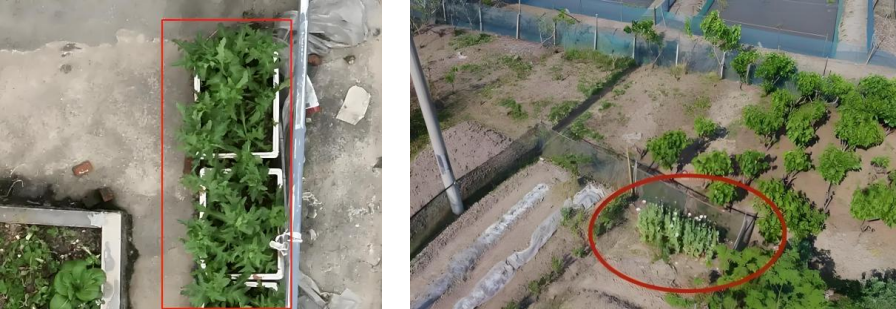
2. Concealed Planting in Rural Areas:
To deal with mixed planting camouflage (such as mixed planting with onions and garlic), it is necessary to optimize the selection of multispectral bands and visible light identification capabilities.
Contact us for more details
HENGFEI TECHNOLOGY look forward to working with you to create a better future!
- All
- Product Management
- News
- Introduction
- Enterprise outlets
- FAQ
- Enterprise Video
- Enterprise Atlas
Low-altitude economy integrated operation service center
HENGFEI TECHNOLOGY
Telephone:183-0095-0096 (Mr. Deng)
157-6163-4439(Mr. Gao)
E-mail:418903183@qq.com
Operating Headquarters: 24th Floor, Lie Yi International Plaza Office Building, 318 Jinyang North Road, Guanshan Lake District, Guiyang City, Guizhou Province
Production Base: 4th Floor, Factory Building 10, Jinhua Town Intelligent Network Automobile Industrial Park (Nanyuan), Guanshan Lake District, Guiyang City, Guizhou Province
Focus on us
Sweep and add customer service
Copyright © Guizhou Hengfei Technology Co., Ltd. 2025 (gzhfkj.net) All Rights Reserved. Website Construction:Zhonqi Power Guiyang