

-
HengfeiGuizhou Hengfei Technology Co., Ltd., relying on a comprehensive and advanced full-industry-chain ecosystem thinking and industrial development concept, builds an integrated system covering general assembly integration, R&D, production and manufacturing, general aviation services, full-industry-chain services, application scenario construction, and low-altitude economic integrated application operation services derived from the industrial chain; providing professional technology, equipment supply, professional personnel, solutions, supporting facilities, and financing for comprehensive services.

-
ProductIs a low-altitude economic comprehensive operation service provider integrating the manufacturing and sales of intelligent unmanned aerial vehicles, the research and development of intelligent robots, the development of low-altitude economic application scenarios, flight training, general aviation services, surveying and mapping, technical services, and technical consulting.

-
ApplicationIs a low-altitude economic comprehensive operation service provider integrating the manufacturing and sales of intelligent unmanned aerial vehicles, the research and development of intelligent robots, the development of low-altitude economic application scenarios, flight training, general aviation services, surveying and mapping, technical services, and technical consulting.

-
R&DGuizhou Hengfei Technology Co., Ltd., relying on a comprehensive and advanced full-industry-chain ecosystem thinking and industrial development concept, builds an integrated system covering general assembly integration, R&D, production and manufacturing, general aviation services, full-industry-chain services, application scenario construction, and low-altitude economic integrated application operation services derived from the industrial chain; providing professional technology, equipment supply, professional personnel, solutions, supporting facilities, and financing for comprehensive services.
-
TrainingStarting in 2020, we began using drones in the traditional industry, and the company sent four people to learn how to fly drones and obtain pilot licenses issued by the Civil Aviation Administration. In line with the national development direction, the company initiated a transformation, conducting research and investigations into 16 low-altitude economic industries nationwide.

-
IndustryIs a low-altitude economic comprehensive operation service provider integrating the manufacturing and sales of intelligent unmanned aerial vehicles, the research and development of intelligent robots, the development of low-altitude economic application scenarios, flight training, general aviation services, surveying and mapping, technical services, and technical consulting.

-
ContactGuizhou Hengfei Technology Co., Ltd., relying on a comprehensive and advanced full-industry-chain ecosystem thinking and industrial development concept, builds an integrated system covering general assembly integration, R&D, production and manufacturing, general aviation services, full-industry-chain services, application scenario construction, and low-altitude economic integrated application operation services derived from the industrial chain; providing professional technology, equipment supply, professional personnel, solutions, supporting facilities, and financing for comprehensive services.


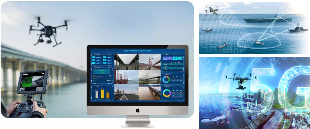
Smart Public Security
The ability to patrol, investigate, and strike "around the clock and in all areas"; big data visualization analysis, system automatic identification and early warning; real-time grasp of dynamics, maximizing police efficiency; a three-dimensional patrol model of "air + ground", realizing all-round and seamless patrol; realizing effective integration of data across police types, departments, and systems to establish a sound information chain management; intelligent prediction and analysis in command and dispatch, police deployment, and security prevention, to develop more detailed work plans.

Intelligent Transportation
Low cost and quick and convenient image acquisition; high efficiency and rapid response; strong anti-interference ability of the equipment; seamless docking with the video surveillance system; strong mobility and good work continuity; less affected by climate and geographical conditions; much stronger video transmission capability; multi-departmental joint data sharing and common viewing

Intelligent Emergency Response
Real-time monitoring of on-site footage, aggregation of various disaster information to aid rescue efforts; promoting the intelligent transformation of emergency rescue equipment, contributing to the construction of an intelligent emergency response system; mobile and flexible, improving the efficiency of emergency rescue material transportation, buying valuable time for rescue; effectively ensuring the safety of rescue personnel; significantly improving the efficiency of emergency rescue; quickly analyzing real-time disaster situations to provide decision-making basis for the deployment of emergency rescue forces; accurate post-disaster analysis to provide data support for post-disaster reconstruction; high degree of timeliness and accuracy, significantly reducing costs, reducing inspection rates, and reducing inefficient manual labor output

Intelligent Firefighting
Visualized data assists in the orderly progress of assessment and repair work; replacing manual large-scale inspection work, reducing labor costs, and improving inspection efficiency
Smart City Management
Visually displays the distribution and location of illegal constructions; Provides a decision-making basis for the urban management department to formulate governance plans; Visualizes data, enabling data scheduling and traceability; Integrates GIS technology to achieve digital management of urban assets; Breaks down barriers between multiple departments; Empowers urban planning and layout needs; Visualized three-dimensional base realizes transparent urban management; An orderly closed-loop processing process efficiently empowers urban management; Significantly improves the frequency and scope of inspections, reducing the rate of missed inspections

Intelligent Environmental Protection
Comprehensive monitoring, reducing monitoring difficulty, increasing monitoring coverage, and avoiding blind spots in random checks; the distribution of gas emissions is clear at a glance, quickly identifying pollution sources; improving patrol efficiency to ensure detection without blind spots; comprehensively controlling environmental conditions and promptly eliminating pollution risks; a three-dimensional perspective provides a visual basis for decision-making in environmental remediation; significantly reducing input costs and improving regulatory efficiency

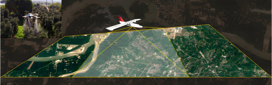
Smart Agriculture
Improve work efficiency and avoid errors caused by manual measurement; scientifically manage farmland, allowing managers to clearly understand the nutrient content of the land; improve operational efficiency, reduce costs, and free up labor; provide accurate data to ensure the accuracy of farmland compensation.

Smart Power
Complete inspection tasks quickly and accurately, improving work efficiency; reduce risks to personnel, avoiding safety hazards such as falls from heights, and improving work safety; not limited by complex terrain and environment, able to perform tasks in harsh weather and terrain conditions; support fully automated inspection programs to ensure data reliability.

Intelligent Aerial Surveying
Intelligent aerial surveying is a method of aerial surveying that integrates advanced technologies. Compared with traditional aerial surveying, it has many advantages in terms of efficiency, accuracy, and data processing.
Smart Emergency Response
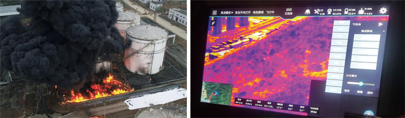
Emergency Response to a Factory Explosion in Chengdu
In February 2020, a methanol storage tank feed pipe at a factory in Longquan District, Chengdu leaked and exploded, causing 5 people to faint from poisoning and a secondary fire in a neighboring residential area, trapping over 20 residents in high-rise buildings. The situation was critical. Under the unified command and dispatch of the Chengdu Emergency Committee, relying on information-based emergency command methods and utilizing modern communication technologies such as drones and single-soldier transmission, rescue supplies were delivered 6 times totaling 25 kg, drones launched fire extinguishing bombs 4 times, and 1 rescue rope was set up. City and district (county) governments, along with 30 city-level departments and 10 working groups, responded swiftly, forming a joint force and providing precise rescue efforts. The dangerous situation was effectively controlled, and the residents were properly resettled.
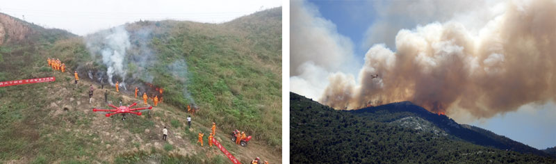
Emergency Rescue for Sichuan Forest Fire
At approximately 6 PM on March 30, 2019, a forest fire occurred in Muli County, Liangshan Prefecture, Sichuan Province. The emergency plan for sudden events was immediately activated, with a drone carrying a high-definition camera providing 24/7 real-time monitoring of the on-site communication network. A 4G drone high-altitude base station was also set up to support rescue command.
Value of the Plan
☆ Real-time grasp of the scene, summarizing various disaster information to assist rescue efforts;
☆ Promoting the intelligent transformation of emergency rescue equipment and assisting in the construction of a smart emergency system;
☆ Mobile and flexible, improving the efficiency of emergency rescue material transportation, and buying valuable time for rescue;
☆ Effectively ensuring the safety of rescue personnel; greatly improving the efficiency of emergency rescue;
☆ Rapid analysis of real-time disaster situation, providing a decision-making basis for the deployment of emergency rescue forces;
☆ Post-disaster precise analysis to provide data support for post-disaster reconstruction;
☆ High degree of unity in timeliness and accuracy, significantly reducing costs, reducing the false negative rate, and reducing inefficient manual labor output;
Smart Public Security Solution
 |
 |
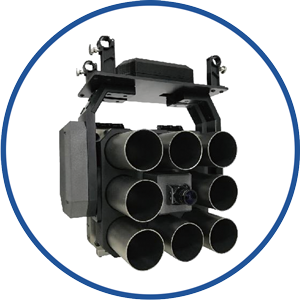 |
| Flight Platform | Search and Patrol Equipment | Rescue Equipment |
 |
 |
|
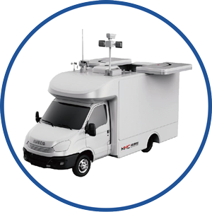
| Command Vehicle | Intelligent system platform |

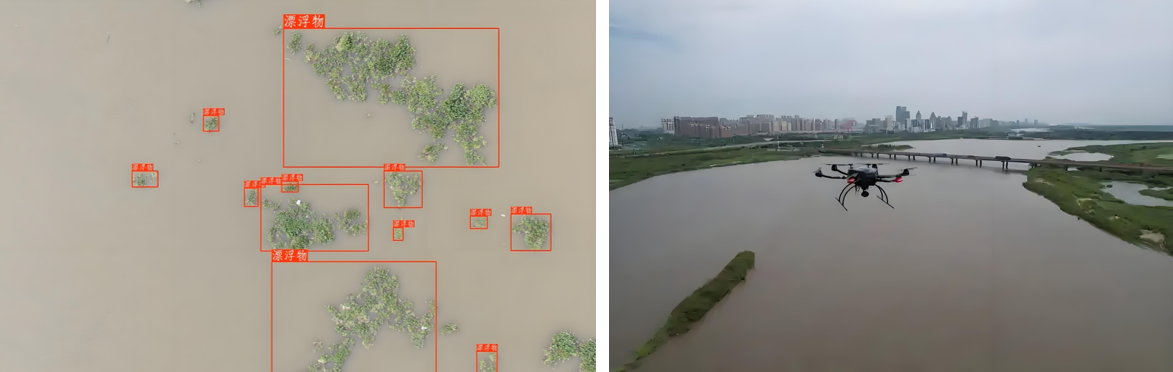
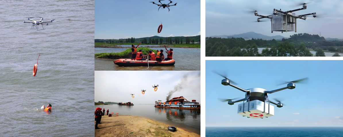
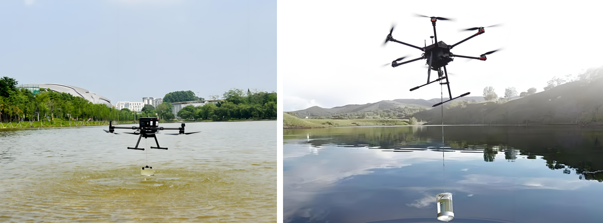
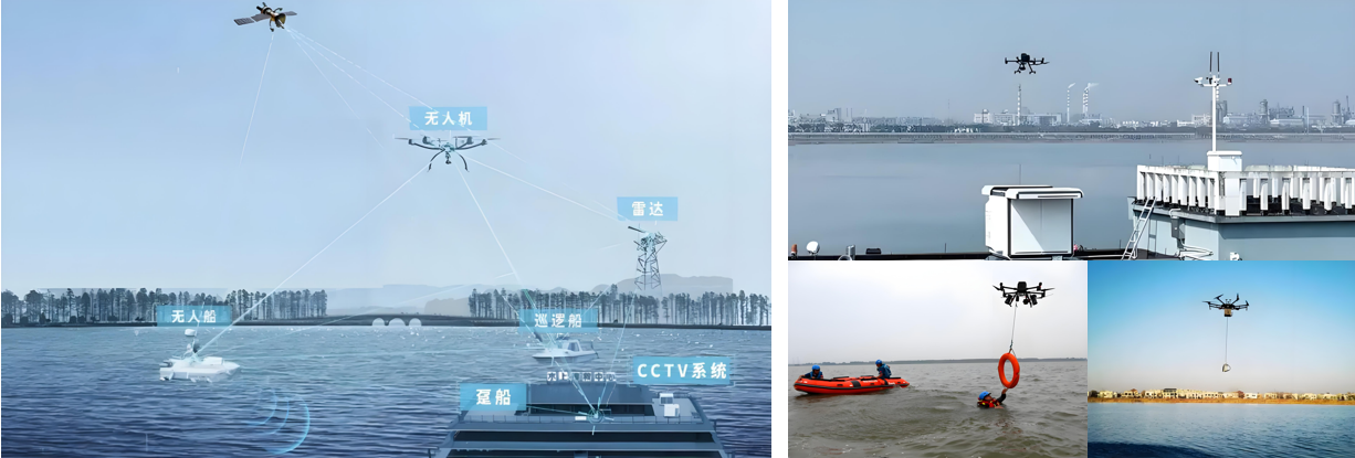
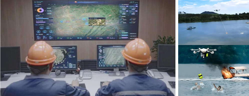
Drone Water Rescue Application Scenario Plan
● Regular Inspection | Inspection Content
Rapid search and rescue: target identification, multi-dimensional reconnaissance, etc.
Emergency supplies delivery and support: remote throwing, medical supplies transportation, etc.
Environmental monitoring and pollution control: water quality and pollution monitoring, hydrological data collection, etc.
Communication and collaborative work support: emergency communication relay, cluster collaboration, etc.
● Regular Inspection | Equipment
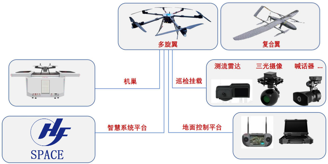
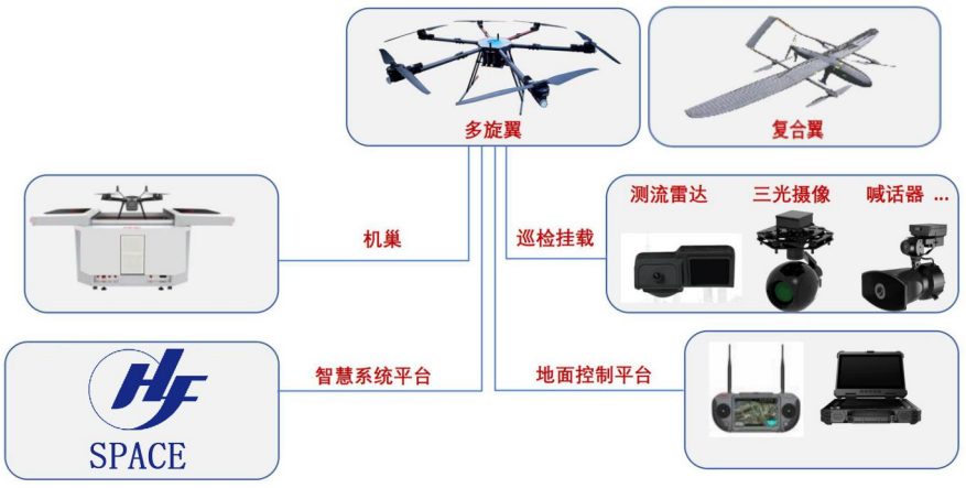
I. Platform Construction
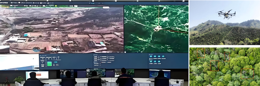
This system mainly includes an AI video intelligent analysis system (developing an AI model library, automatically identifying parameters such as crack width and rust area, quantifying damage, etc.), mobile video management and analysis, drone video management and analysis by section, and radar data intelligent analysis. Through the construction of a smart command platform, task setting, route planning, automatic identification, risk warning data storage and processing are realized, meeting the needs of water traffic congestion warning, facility water area inspection, emergency command, and illegal evidence collection, etc.
II. BIM Information Input
Using a modular architecture, a basic application support platform is built, including BIM models, GIS data, BIM+GIS engine, BPM process engine, BI analysis tools, integrated communication system, unified identity authentication service, digital twin engine, simulation decision-making engine, vehicle-road collaboration engine, Beidou high-precision positioning service, and mobile APP, providing support for various businesses in SaaS (business application layer).
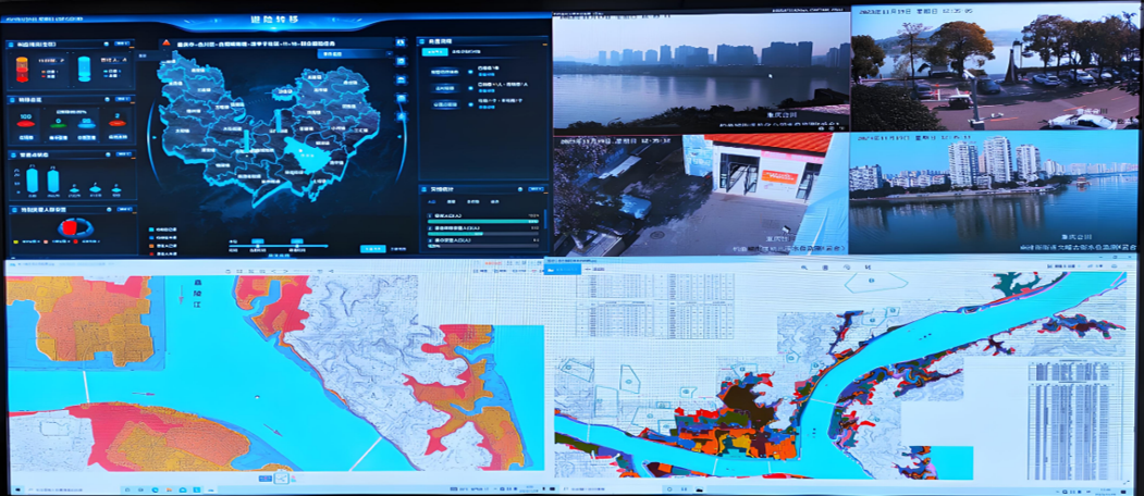
III. Building a 5G Platform
Combining 5G network to transmit data in real-time to the command center, linking the traffic signal system. Developing an event priority algorithm to automatically trigger emergency tasks (such as accident scene blockade, material delivery, etc.).
IV. Drone + Nest
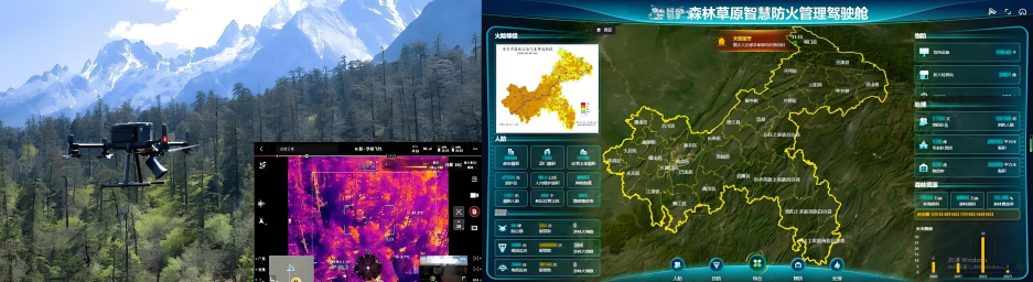
Drone Forestry Application Scenario Plan
How to Prevent: Building an All-Weather Stereoscopic Forest Protection Network
● Daily Hidden Danger Inspection | Inspection Content
Forest fire prevention and early warning and fire source monitoring:
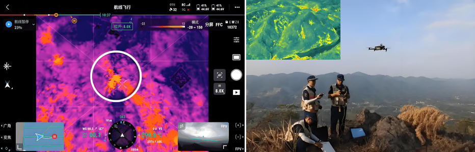
Dual-light fusion technology: combining visible light and thermal imaging for all-weather fire monitoring. For example: The payload can penetrate smoke at night to identify hidden fire sources.
Intelligent alarm system: automatically analyzes image data, triggers fire alarms, and synchronizes coordinates to the command center.
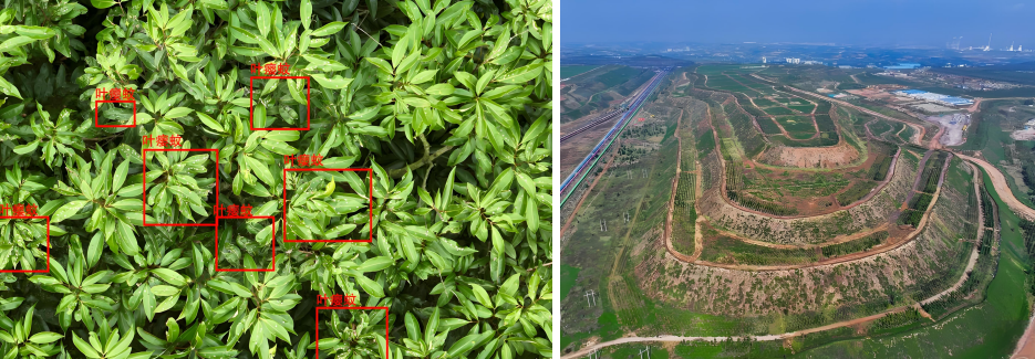
Intelligent diagnosis and prevention of pests and diseases:
Precise medication: equipped with atomizing spray heads, combined with route planning to achieve grid spraying, reducing drug waste.
Data modeling: generating a three-dimensional forest model using lidar to locate high-incidence areas of pests and diseases.
Ecological protection and wildlife monitoring:
AI recognition algorithm: automatically identifies rare species and counts population numbers.
Habitat protection: evaluating ecological restoration effects through aerial photography data to guide vegetation restoration projects.
How to Patrol: Intelligent Inspection System Improves Forest Management Efficiency
● Daily Hidden Danger Inspection | Inspection Content
Daily patrol mode innovation:
Route planning and automated inspection: Based on the GIS system to plan routes, drones automatically cover a 50-meter range on both sides of the route, with a single task capable of inspecting 2000 mu of forest land, taking only 10 minutes, improving efficiency by 12 times compared to manual inspection.
Complex terrain breakthrough: Drones can traverse dense forests, cliffs, and other dangerous areas, ensuring flight safety through lidar obstacle avoidance technology.
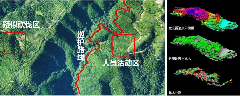
Resource survey and law enforcement supervision:
Forestland Occupancy Monitoring: Through regular aerial photography and image comparison, illegal land occupation and deforestation are detected. For example, the Dailing Forestry Bureau used drones to investigate and handle 3 cases of illegal destruction, increasing the efficiency of investigation by 6 times.
Law Enforcement Evidence Collection: Equipped with a 20-megapixel camera, it captures high-definition evidence and transmits it in real-time, supporting forestry administrative penalties.
Flood Season and Geological Disaster Prevention:During the flood season, drones monitor river water levels and landslide risks in real-time. Real-time image transmission assists emergency departments in rapid response.

How to Rescue: Integrated Air-Ground Emergency Rescue System
● Daily Hidden Danger Inspection | Inspection Content
Forest Fire Emergency Response:
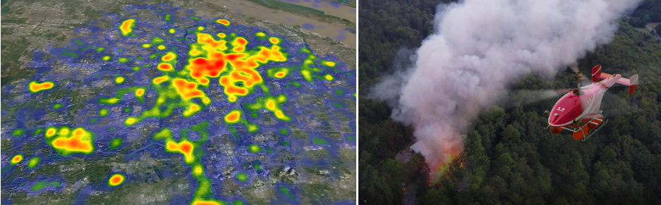
Fire Scene Investigation and Command Assistance: Drones generate real-time three-dimensional heat maps over the fire scene, marking the fire line length and direction of spread, providing decision-making basis for the command center.
Material Delivery and Communication Relay: Large drones can deliver fire extinguishing bombs and first-aid kits, and build temporary communication networks to ensure the coordination of rescue teams.
Personnel Search and Rescue and Emergency Linkage:
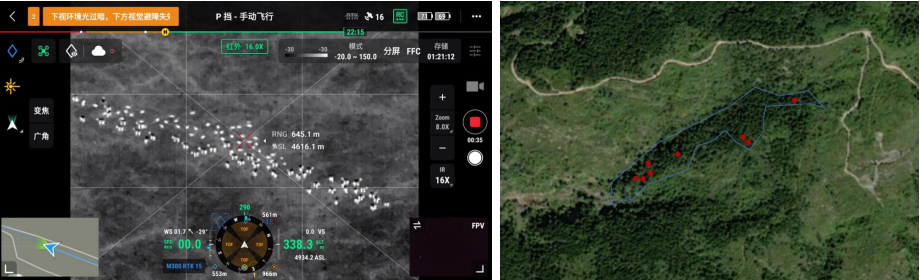
Missing Person Location: Equipped with thermal imaging and a loudspeaker, drones can quickly locate trapped people during night-time search and rescue.
Integrated Air-Ground Fire Fighting: Pilots, ground fire fighting teams, and the command center share data in real-time via 5G, achieving a closed-loop of "detection-location-extinguishing".
Post-disaster Assessment and Ecological Restoration:
Disaster Damage Survey: Drones generate high-precision orthographic images, quickly assessing the burnt area and timber losses.
Restoration Monitoring: Regular aerial photography tracks vegetation restoration progress, guiding replanting and soil and water conservation projects.

Routine Inspection | Equipment Configuration
I. Platform Construction
This system mainly includes AI video intelligent analysis system, mobile video management and analysis, unmanned aerial vehicle video management and analysis by section, and radar data intelligent analysis.
Through the construction of a command intelligence platform, task setting, route planning, automatic identification, risk warning data storage and processing, forestry inspection, emergency command, and illegal evidence collection are achieved.
II. BIM Information Input
Adopting a modular architecture, a basic application support platform is built, including BIM models, GIS data, BIM+GIS engine, BPM process engine, BI analysis tools, integrated communication system, unified identity authentication service, digital twin engine, simulation decision-making engine, vehicle-road collaboration engine, Beidou high-precision positioning service, mobile APP, etc., providing support for various businesses in Saas (business application layer).

III. UAV + Nest
Contact us for more details
HENGFEI TECHNOLOGY look forward to working with you to create a better future!
- All
- Product Management
- News
- Introduction
- Enterprise outlets
- FAQ
- Enterprise Video
- Enterprise Atlas
Low-altitude economy integrated operation service center
HENGFEI TECHNOLOGY
Telephone:183-0095-0096 (Mr. Deng)
157-6163-4439(Mr. Gao)
E-mail:348771149@qq.com
Operating Headquarters: 24th Floor, Lie Yi International Plaza Office Building, 318 Jinyang North Road, Guanshan Lake District, Guiyang City, Guizhou Province
Production Base: 4th Floor, Factory Building 10, Jinhua Town Intelligent Network Automobile Industrial Park (Nanyuan), Guanshan Lake District, Guiyang City, Guizhou Province
Focus on us
Sweep and add customer service
Copyright © Guizhou Hengfei Technology Co., Ltd. 2025 (gzhfkj.net) All Rights Reserved. Website Construction:Zhonqi Power Guiyang