

-
HengfeiGuizhou Hengfei Technology Co., Ltd., relying on a comprehensive and advanced full-industry-chain ecosystem thinking and industrial development concept, builds an integrated system covering general assembly integration, R&D, production and manufacturing, general aviation services, full-industry-chain services, application scenario construction, and low-altitude economic integrated application operation services derived from the industrial chain; providing professional technology, equipment supply, professional personnel, solutions, supporting facilities, and financing for comprehensive services.

-
ProductIs a low-altitude economic comprehensive operation service provider integrating the manufacturing and sales of intelligent unmanned aerial vehicles, the research and development of intelligent robots, the development of low-altitude economic application scenarios, flight training, general aviation services, surveying and mapping, technical services, and technical consulting.

-
ApplicationIs a low-altitude economic comprehensive operation service provider integrating the manufacturing and sales of intelligent unmanned aerial vehicles, the research and development of intelligent robots, the development of low-altitude economic application scenarios, flight training, general aviation services, surveying and mapping, technical services, and technical consulting.

-
R&DGuizhou Hengfei Technology Co., Ltd., relying on a comprehensive and advanced full-industry-chain ecosystem thinking and industrial development concept, builds an integrated system covering general assembly integration, R&D, production and manufacturing, general aviation services, full-industry-chain services, application scenario construction, and low-altitude economic integrated application operation services derived from the industrial chain; providing professional technology, equipment supply, professional personnel, solutions, supporting facilities, and financing for comprehensive services.
-
TrainingStarting in 2020, we began using drones in the traditional industry, and the company sent four people to learn how to fly drones and obtain pilot licenses issued by the Civil Aviation Administration. In line with the national development direction, the company initiated a transformation, conducting research and investigations into 16 low-altitude economic industries nationwide.

-
IndustryIs a low-altitude economic comprehensive operation service provider integrating the manufacturing and sales of intelligent unmanned aerial vehicles, the research and development of intelligent robots, the development of low-altitude economic application scenarios, flight training, general aviation services, surveying and mapping, technical services, and technical consulting.

-
ContactGuizhou Hengfei Technology Co., Ltd., relying on a comprehensive and advanced full-industry-chain ecosystem thinking and industrial development concept, builds an integrated system covering general assembly integration, R&D, production and manufacturing, general aviation services, full-industry-chain services, application scenario construction, and low-altitude economic integrated application operation services derived from the industrial chain; providing professional technology, equipment supply, professional personnel, solutions, supporting facilities, and financing for comprehensive services.


Low-altitude economy integrated operation service center
Low-altitude economy integrated operation service center
HENGFEI TECHNOLOGY
Low-altitude economy integrated operation service center
Guizhou Hengfei Technology Co., Ltd. was established on January 12, 2024, and is an investment attraction enterprise in Guanshanhu District, Guiyang City, Guizhou Province. The company adheres to a comprehensive and advanced layout of the entire industry chain ecosystem and industrial development concept in its development, creating a comprehensive operation service that integrates intelligent unmanned aerial vehicle manufacturing, sales, intelligent robot research and development, low altitude economic application scenario development, flight training, general aviation services, surveying and mapping, technical services, application scenario construction, and industrial chain derivative expansion. It also provides professional technology, equipment supply, professional talents, solutions, supporting facilities and other support. Due to development needs, the company currently has three office spaces, as follows: 1. 24th floor of Liebian International Plaza: the company's research and development, operation, and business headquarters; 2. Guanshanhu Intelligent Manufacturing Industrial Park: Product Processing and Manufacturing Center, CAAC UAV License Training Center; 3. Eagle Mountain Factory in Shawen Town, Baiyun District: a research and development testing base for turbojet engines and a testing center for high-speed motor energy conversion.
Learn more →The company was established in
Company registered capital
Class A qualification

Product Application
A set of intelligent unmanned aerial vehicle manufacturing, sales, intelligent robot research and development as one of the low-altitude economic integrated operation service providers.

Product application scenarios
Smart Public Security

The ability to patrol, investigate, and strike "around the clock and in all areas"; big data visualization analysis, system automatic identification and early warning; real-time grasp of dynamics, maximizing police efficiency; a three-dimensional patrol model of "air + ground", realizing all-round and seamless patrol; realizing effective integration of data across police types, departments, and systems to establish a sound information chain management; intelligent prediction and analysis in command and dispatch, police deployment, and security prevention, to develop more detailed work plans.
Learn more →
Product application scenarios
Intelligent Transportation
Low cost and quick and convenient image acquisition; high efficiency and rapid response; strong anti-interference ability of the equipment; seamless docking with the video surveillance system; strong mobility and good work continuity; less affected by climate and geographical conditions; much stronger video transmission capability; multi-departmental joint data sharing and common viewing
Learn more →
Product application scenarios
Intelligent Emergency Response
Real-time monitoring of on-site footage, aggregation of various disaster information to aid rescue efforts; promoting the intelligent transformation of emergency rescue equipment, contributing to the construction of an intelligent emergency response system; mobile and flexible, improving the efficiency of emergency rescue material transportation, buying valuable time for rescue; effectively ensuring the safety of rescue personnel; significantly improving the efficiency of emergency rescue; quickly analyzing real-time disaster situations to provide decision-making basis for the deployment of emergency rescue forces; accurate post-disaster analysis to provide data support for post-disaster reconstruction; high degree of timeliness and accuracy, significantly reducing costs, reducing inspection rates, and reducing inefficient manual labor output
Learn more →
Product application scenarios
Intelligent Firefighting
Visualized data assists in the orderly progress of assessment and repair work; replacing manual large-scale inspection work, reducing labor costs, and improving inspection efficiency
Learn more →
Product application scenarios
Smart City Management
Visually displays the distribution and location of illegal constructions; Provides a decision-making basis for the urban management department to formulate governance plans; Visualizes data, enabling data scheduling and traceability; Integrates GIS technology to achieve digital management of urban assets; Breaks down barriers between multiple departments; Empowers urban planning and layout needs; Visualized three-dimensional base realizes transparent urban management; An orderly closed-loop processing process efficiently empowers urban management; Significantly improves the frequency and scope of inspections, reducing the rate of missed inspections
Learn more →
Product application scenarios
Intelligent Environmental Protection
Comprehensive monitoring, reducing monitoring difficulty, increasing monitoring coverage, and avoiding blind spots in random checks; the distribution of gas emissions is clear at a glance, quickly identifying pollution sources; improving patrol efficiency to ensure detection without blind spots; comprehensively controlling environmental conditions and promptly eliminating pollution risks; a three-dimensional perspective provides a visual basis for decision-making in environmental remediation; significantly reducing input costs and improving regulatory efficiency
Learn more →
Product application scenarios
Smart Agriculture
Improve work efficiency and avoid errors caused by manual measurement; scientifically manage farmland, allowing managers to clearly understand the nutrient content of the land; improve operational efficiency, reduce costs, and free up labor; provide accurate data to ensure the accuracy of farmland compensation.
Learn more →
Product application scenarios
Smart Power
Complete inspection tasks quickly and accurately, improving work efficiency; reduce risks to personnel, avoiding safety hazards such as falls from heights, and improving work safety; not limited by complex terrain and environment, able to perform tasks in harsh weather and terrain conditions; support fully automated inspection programs to ensure data reliability.
Learn more →
Product application scenarios
Intelligent Aerial Surveying
Intelligent aerial surveying is a method of aerial surveying that integrates advanced technologies. Compared with traditional aerial surveying, it has many advantages in terms of efficiency, accuracy, and data processing.
Learn more →Qualification Honor
A set of intelligent unmanned aerial vehicle manufacturing, sales, intelligent robot research and development as one of the low-altitude economic integrated operation service providers.
Low-altitude economy integrated operation service center
Fill in your requirements, we will contact you as soon as we receive it and give you a complete solution!
Provide intelligent drone solutions
Please fill in your information correctly so that we can contact you more quickly!
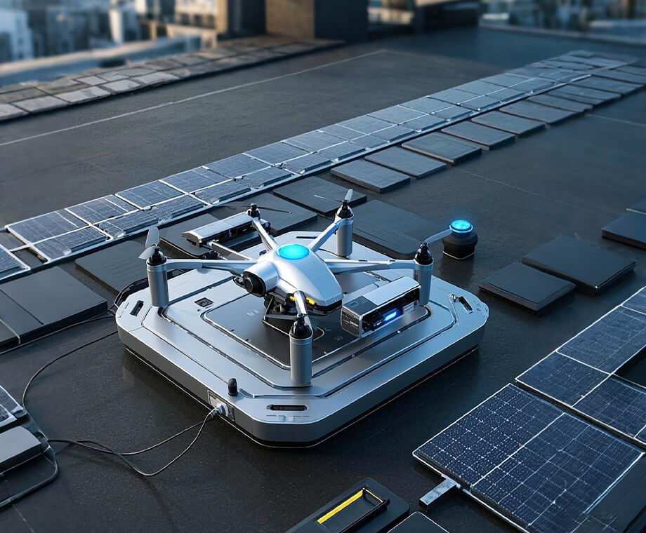
R & D strength
A set of intelligent unmanned aerial vehicle manufacturing, sales, intelligent robot research and development as one of the low-altitude economic integrated operation service providers.
-

Development of hybrid new energy technology
With the development of technology, hybrid new energy technology will move towards higher efficiency, longer pure electric range, and smarter energy management. On the airplane, an intelligent flight control system is used to automatically adjust the flight attitude and respond to sudden weather changes.
Supercharging development Responding to sudden weather changes Longer pure electric rangeMore intelligent energy management
-
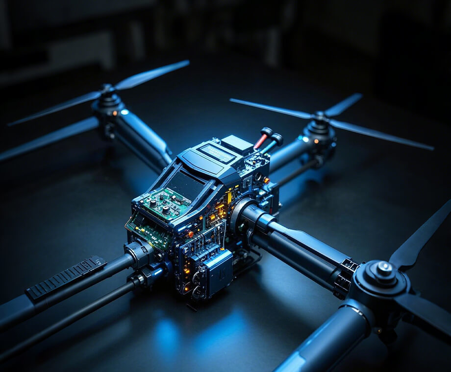

Avionics system
Drone image transmission processing and transmission, drone flight control, measurement and control, wireless data transmission, and other supporting products
UAV image processing UAV flight control systemUAV measurement sensor moduleNavigation receiver
-
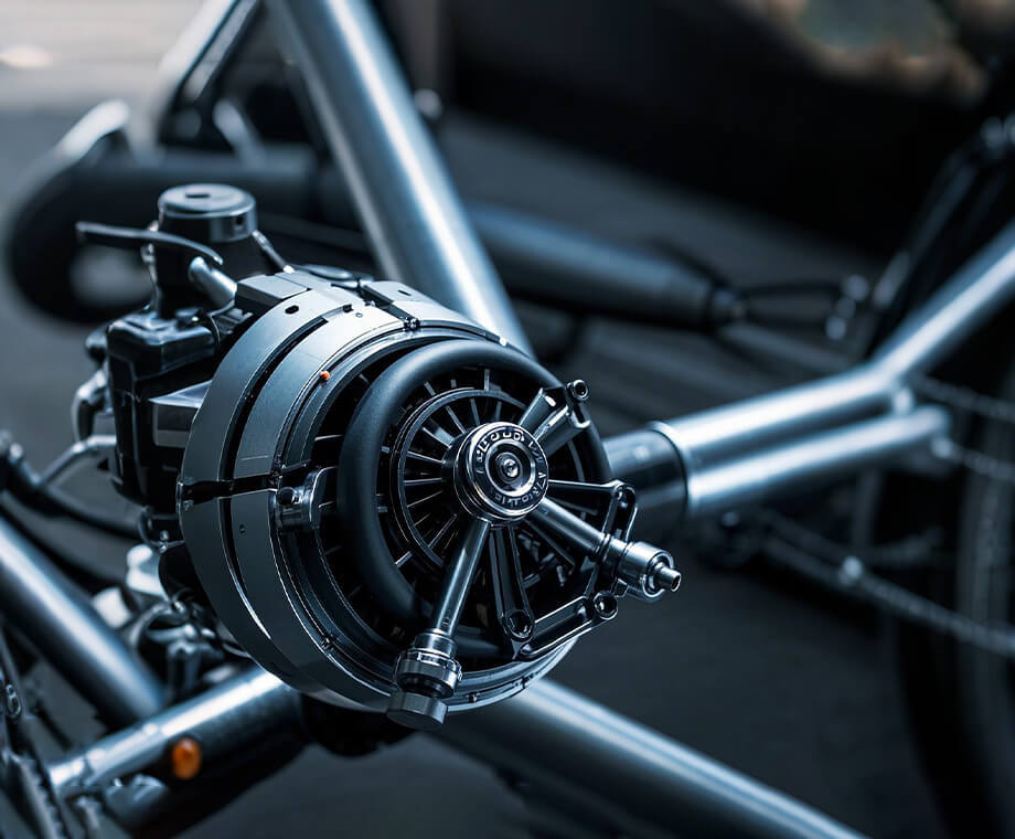

High speed turbojet engine
Fixed wing jet unmanned aerial vehicle: developing capable of performing high-speed, high-altitude, and long-range missions (60-80daN micro turbofan engine under development); Vortex axis unmanned helicopter or turboprop fixed wing aircraft: capable of carrying large loads, long-range disaster relief, border defense, stability maintenance tasks, power grid, oil pipeline, forest firefighting inspections, etc
Design of Turbine Engine ECU Design of Turbine GeneratorDesign of Gas Turbine GeneratorTurbojet engine
-


Drones equipped with high-energy laser countermeasure technology
Drones equipped with high-energy lasers can intercept incoming missiles, drones, and other aerial targets; By utilizing the ranging function of high-energy lasers, drones can more accurately measure the distance and position information of targets. In maritime operations, the high-energy lasers carried by drones can be used to attack small ships at sea or interfere with or damage sensitive parts of large ships, such as radar and electro-optical equipment
Air target interception Utilizing the distance measurement function of high-energy lasersInterference or destruction
R & D strength
A set of intelligent unmanned aerial vehicle manufacturing, sales, intelligent robot research and development as one of the low-altitude economic integrated operation service providers.
Contact us for more details
HENGFEI TECHNOLOGY look forward to working with you to create a better future!
- All
- Product Management
- News
- Introduction
- Enterprise outlets
- FAQ
- Enterprise Video
- Enterprise Atlas
Low-altitude economy integrated operation service center
HENGFEI TECHNOLOGY
Telephone:183-0095-0096 (Mr. Deng)
157-6163-4439(Mr. Gao)
E-mail:348771149@qq.com
Operating Headquarters: 24th Floor, Lie Yi International Plaza Office Building, 318 Jinyang North Road, Guanshan Lake District, Guiyang City, Guizhou Province
Production Base: 4th Floor, Factory Building 10, Jinhua Town Intelligent Network Automobile Industrial Park (Nanyuan), Guanshan Lake District, Guiyang City, Guizhou Province
Focus on us
Sweep and add customer service
Copyright © Guizhou Hengfei Technology Co., Ltd. 2025 (gzhfkj.net) All Rights Reserved. Website Construction:Zhonqi Power Guiyang